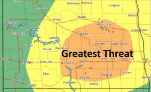
JAMESTOWN, N.D. (NewsDakota.com) – The Bismarck National Weather Service says more severe weather could be possible beginning Tuesday afternoon in the James River Basin.
Meteorologist Janine Vining reports that the significant severe weather event is expected across central, eastern, and portions of southwestern North Dakota.
Vining says once that occurs, the system will become more widespread and bring some severe storms to the state.
Based on models and forecasts, Vining says the Weather Service has high confidence in the storm striking the region.
The storm is expected to bring large hail the size of baseballs, damaging wind gusts of up to 70 mph, heavy rainfall, and possibly a few tornadoes.
Vining says individuals need to stay up to date with the latest forecasts as the storm could strike very quickly in any area.
Stay tuned to your local i3G Media station for the latest weather details.

